Andy Dubreuil Photography

Jumping to get that image.

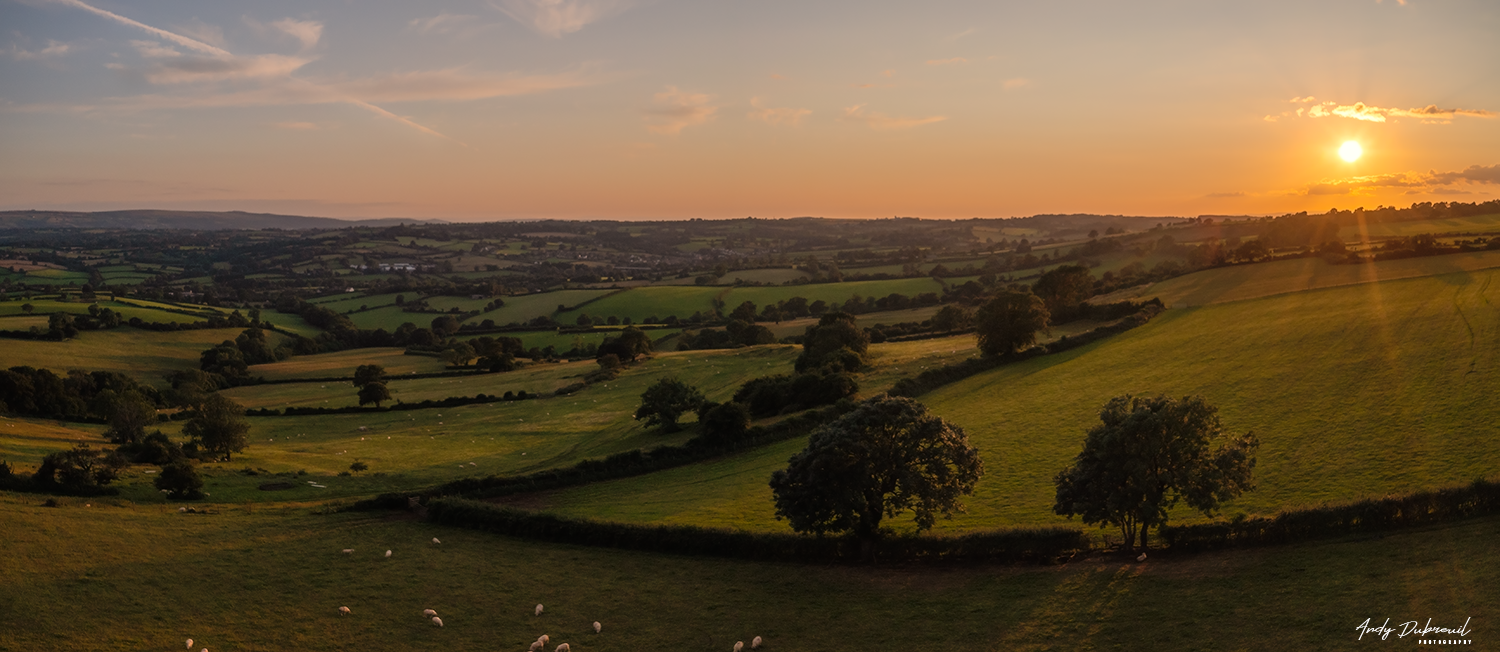
I posted an image in Facebook groups that I belong to and enjoy seeing others work and sharing my own, the image was called the Hobbit Field and I had pointed out that I wasn’t giving details of location as I normally do, so not to bring a big discussion over the image and maybe people not going about it in the right way doing something similar. So I’ve decided to explain in a blog post that makes it easier to explain and show images to help explain things in more detail.

The Hobbit Field

The Hobbit Field

Top of the hill

Living in Bristol has most things that any thriving city needs, including places of beauty close by with rolling hills and lakes, but also includes a busy airport. 

There is a great location overlooking the South of Somerset and the beauty it holds that can be seen for miles at the top of Dundrey hill as it’s known, but has restricted views from the road and lay-bys it has, specially for someone like me in a wheelchair.

Sunset on Hobbit Field

Sunset on Hobbit Field

Research NATS 

The NATS app also known as Drone Assist by Flight Angels gives a great view of the area with restrictions that are in place like CRT and FRZ that are the important ones to follow and understand. 

Having a CRT zone in my area that I fly regularly, I have the Air Traffic Control phone number in my phone and always ring them with my details and duration of flight. Some will say you don’t have to contact them, but I prefer to so they know I’m in the area if there was a aircraft emergency like what happened a week ago when a Easy Jet was had a bird strike abs had to make an emergency return to the airport that might of meant it didn’t stick to the routine flight area. 

With the FRZ you have to contact the air traffic control or file for permission through NATS via their website to gain permission. 

You need the coordinates of your point of takeoff and land abs give details of flight, time, contact number and do a risk assessment. 

Gaining Permission 

I contacted the Bristol Air Traffic Control beforehand to find out if a flight was possible from the location I had chosen and gave my details of A2 CofC certified, operator ID, drone, duration of flight, type of aircraft and maximum height as well as setting out cone off area and helipad to land on. My location is just over 2,000m from the FRZ so not actually in the space that would have needed me to file for a permission with NATS and can be decided by ATC. 

Image shows Airport flight zones and my location.

Image shows Airport flight zones and my location.

You can see from the image the airport zone and my location on the map.

I had to take into account that being on a hill that is 160m above sea level, this means I’m going to be that close to an aircraft coming over me. 

In my research I waited for an aircraft to fly over to see how close it would be, and I can say I could see nearly everything on the craft and the wheels were down ready to land! At the location using FlightRadar24, I could see the actual height at my location the aircraft would be 1300ft above me; that’s 396.24m and thats close

So my maximum height was thought to be maybe 50m but I changed this to under 20m to be extra safe.  

I did a small video but took over 180 images of the sunset which was the main purpose of the flight. I could of waited for for an aircraft to come overhead to capture an image with the drone, but this would had started a bee’s nest of accusations and feed into hysteria on what I had done, but I was not going to risk my license of the drone community to be destructive in doing so and see it as irresponsible, which I'm not. 

I used up one battery and as I had landed I got a call from the ATC to say another aircraft was inbound but I had decided not to fly anymore and thanked them for their time and support and they said anytime. 

My point of view. 

It might seem a lot of hassle but it was a couple of two minute calls with support from the ATC and doing a simple and logical risk assessment. Showing being responsible puts the positive into what could be the negative. If the pilot had seen me with high vis jacket on and a visible helipad, he might of given ATC a call with concerns but I believe that ATC gives the pilots the heads up of my presence and that I should not be of any danger to them in my drone being to high and could cause a collision. Respect is given when earned. 

This blog isn’t to exonerate myself from anything but to highlight what I did and why that has given me the benefit of an image that would be hard for anyone to do unless they follow the rules.

Update - Drone Photography

Into today’s world, technology moves so fast that by the time you’ve got use to your new piece of tech kit, something else has come along to replace it as soon as.

When I got my first DJI drone, the Mavic Air, which has a F2.8 aperture giving 12MP RAW and JPWG images, and 4K video with 30-120 FPS. I thought it was great. 

DJI Mavic Pro2

DJI Mavic Pro2

But within two months DJI brought out the DJI Mavic Pro 2, with its 1” Hasselblad gimbal camera giving 20MB RAW and JPEG images with an f-stop from F2.8/F11 and 4K video with 30-120 FPS.

The drone is larger and does make a difference in being able to see in the sky, but apart from the battery use time, which is around 30 minutes and longer than the Mavic Air, its the camera for me that makes all the difference and why I invested in the Mavic Pro 2.

The Gimbal Camera

When you look at the image of the Mavic Pro 2, the camera looks small and uninspiring, but it actually has all the features of an SLR camera.

  • White Balance

  • ISO100-12800

  • Shutter speed 8-1/8000s

  • Single shot

  • Burst shot 3/5 frames

  • Auto exposure bracketing (AEB) 3/5 bracketed frames t 0.7EV Bias

Screenshot live feed and camera controls

Screenshot live feed and camera controls

It’s unbelievable that such a small camera is packed with all these features, yet the control is done by the app on a phone or tablet connected to the drone controller and works wirelessly. You can do some clever shots like stitching images together, HDR, long exposure, bracketing, just to name a few. It’s like having a real camera in your hands, but being able to photograph from up to 400ft high off the ground and choosing your composition from 360 degree angle, the camera sits on 3-axis gimbal and allows you to move up and down, but now also left to right. DJI believe the drone can work in a stable position in winds up to 22mph.

As a photographer, the drone gives you new possibilities on how you photograph the landscape, but also structures by being able to be above and pointing the camera directly down on the subject. Also it allows you to access places which you can’t reach be foot or by chair. The camera comes with a 10-BIT Dlog-M Colour Profile that gives amazing colour to your images right out of the drone, the images are sharp and crisp, giving 20MB RAW or JPEG and gives you a whole lot of image to work with when it comes to post editing, but the image quality is really good out of the camera. It even comes with histogram and over exposure warnings.

4K Video

The DJI Mavic Pro 2 comes with a number of features like ‘tripod mode’ that makes your drone move more slowly, giving that smooth and more accurate movement, great if you flooring a person. Also Hyperlaps video, something that in the passed you needed special equipment and a large camera being able to process so many images taken within a space of time. Now you can be above your subject and have incredible steady footage. The 4K video is smooth and with the use ND filters, you can make professional looking footage that only the most expensive of equipment has been able to do in the past.

This small but powerful drone, gives new life to photography and videography and is a great addition to your kit, which is compact easy to setup within minutes.

Test Flight

I’ve always worked in manual mode, so I set the f-stop to f5.6, ISO 100 and 24fps. The first thing I noticed was how much faster this drone flies, you can get up to a speed of 20mph, which is quicker than the Mavic Air and allows you to get to your point of interest in a shorter time and saves of the battery, so you have more time to film or photograph your subject.

When you take your thumb off the joystick, it comes to a halt really quickly. Being able to see your drone at all times, is part of the regulations and in this test I went out about 800ft, and I have to say I had no problem looking at the drone, then looking at my screen, then back to the drone. This was half the maximum distance, and I'm sure if I gone the max, I would still be able to see the drone clearly.

With the Mavic Pro 2, you have the ability to move the camera up and down, but also left and right by touching the screen on the device app with your finger. You can move the position at max but you can see the front leg of the drone, which is a shame it doesn’t stop before that, but you can edit this out or just be more responsive to correct the camera away from the leg.

The controller comes with buttons which you can customise, but one allows the camera to look directly 90 degrees downwards, clicking again returns it back to its original position, this is really useful and a time saver as the camera moves slowly so not to seem jittery in footage.

Things like I’ve mentioned, saves a lot of time in trying to do it yourself, this means more time in the air and not wasting valuable battery time.

Final Thoughts

Yes the drone is over £1,000, but DJI is at the forefront of hobby and professional drones. They pack so many great features that it literally can fly itself if programmed to. Its safety features means you're not going to crash very easily. It’s been widely reported that it doesn’t use the full 1” sensor but it still is an amazing camera and great quality of images and video. 

You can always if you want to find fault with things, but for the most part, I love this drone and I know its going to add to my workflow and allow me to create interesting images and video that I couldn’t do with my DSLR without having special equipment, but I'm not going to get the great views from ground as I can from the sky with some of my photography. I don't see myself making movies that involve people, as I got this purely for landscape photography. There are limitations as you I can’t use it within a city and unless it's an open area. Rules and regulations are tight and may get tighter, but I'm sure that they wont effect the kind of use that I have in mind for the drone. 

I’ve posted a number of videos on my website already, which was done with the Mavic Air, and to me they look amazing and this new drone is just going to add more time in the air, a real camera control and a bunch of advance features that I'm sure in time will get to use at some point.